As of July, when we set off on our trip, the lava had divided into two flows. One of them had already cooled down, but the other, which we planned to visit, had not yet cooled.
Two o'clock in the morning. Outside it was dark. The sun had only recently dipped down beneath the horizon but very soon there would be a new dawn. That's what summer’s like in Kamchatka. We climbed out of bed in anticipation of our upcoming adventure. Car keys? Check. Backpack? Check. Let's go! Today I'll reach the spot I have wanted to see for the past six months – the Plosky Tolbachik volcano, which is now experiencing a huge eruption.
The headlights of our Suzuki Escudo illuminate the mile markers and traffic signs. We need to catch the ferry in the village of Atlasovo that will take us across the Kamchatka river by 10am. It is almost 450 kilometers (280 miles) away, and only 150 km of those are paved. If we don't make the ferry, we will have to wait 6 hours until the next crossing.
The Kamchatka River is the largest water artery of the peninsula. It is 758 kilometers long (470 miles) and divides the land into north and south parts. Prior to 2012 it could be crossed only by ferries. Now one of them, the biggest, has been replaced by a bridge. But some of the villages across the Kamchatka remain dependent on the ferries, including Lazo. At one time this village was rather large. Life here, as in many remote areas of Kamchatka, began to fade out with the collapse of the Soviet Union. Now, long after that time, it is gradually beginning to recover. But still there are many abandoned houses. People make their living mainly by fishing or agriculture.
We made it across the river. Now we can catch our breath. But before we relax completely, we have to drive another 80 kilometers (50 miles) on a dirt road to the Pravy Tolbachik, a powerful mountain river. This route was cut through the forest a few decades ago for logging. The larch and spruce here grow to a height of 30–35 meters (100–115 feet).
Kamchatka has more than 14,000 rivers and streams. Most of them are at least 10 kilometers (6.2 miles) long. The rivers of Kamchatka are fast flowing and the average long-term flow is about 1,000 cubic kilometers (240 cubic miles), which is one of the highest in Russia.
We have a light snack after crossing our last water barrier and we are again behind the wheel. We still have about 50 km (30 miles) left to go across rugged terrain. The road here is unpaved, and is rarely used. Because of this, it is heavily overgrown with young trees, and now only off-road vehicles can drive on it.
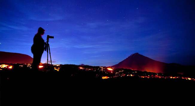
The closer we get to the volcano, the less vegetation we see. Soon instead of bright green trees and larches we see only ashen trunks of dead wood. Instead of ground under our feet, there is a dark slag and the bushy hills have been replaced by the cone of the Big Tolbachinsky fissure eruption. It was this volcano that changed the area beyond recognition in 1975. Molten slag burned everything it touched, and now the landscape is more similar to that on the moon. By the way, during the Soviet Union era they tested lunar rovers here. The base that was built for these tests was destroyed in November 2012 by the lava flow.
It is most convenient to travel through Tolbachinsky valley by car because the distances here are quite large. For example, it takes all day to get from the outermost tip of the cone to the foot of Tolbachik. In an off-road vehicle you can quickly visit many more natural sites. The main thing to remember is that you are in a nature park and it is not permitted to turn off the dirt road. The only way to get to the lava spewing crater is on foot. We spent about an hour on the ascent, taking time to look at all the holes in the fresh lava. It's just an incredible sight that generates a range of emotions. It's scary and exciting at the same time. You understand that it is dangerous to walk on the lava, looking into a fissure with the red-hot magma, but at the same time you cannot stop.
Again, we are on our way. We have about 80 kilometers (50 miles) of dirt road ahead of us through the forest to Kozyrevsk village. Beyond that is Esso with its thermal waters. But a gravel road goes there, which is almost a highway by the standards of the peninsula.
Kamchatka has almost no roads. The only traffic artery originates in Petropavlovsk-Kamchatsky, goes through Yelizovsky district, passes Sokoch village and divides into two. One road goes to the shores of the Sea of Okhotsk to the Oktyabrysky village of Ust-Bolsheretsk region, the other goes to the north, towards Ust-Kamchatsk. There are no other roads, only "directions." Some of them were built by the military, some by geologists, and some were needed to connect the fishing villages on the coast with the world.
That is why in recent years Kamchatka has some of the most off-road vehicles per capital in Russia. Those are the only type of vehicles that can reach various parts of the peninsula. It's just too bad that the travel season for jeeps is rather short. Typically snow falls in November, and some areas become impassible for jeeps. Off-road season won't open then until mid-June. Some brave souls make the first trip around the peninsula at the end of May. However, then they still have to take a break for a few weeks, because the melting snow raises the water level in the rivers and they become impossible to cross.
Where can a person go in Kamchatka? Of course, to the volcanoes, hot springs, waterfalls and coves. With an off-road vehicle you can visit many of the unique parts of the peninsula. In summer you must take a fishing rod. As you are driving, or even during a short lunch, you can take time to go fishing. And, of course, do not forget to bring your camera. Bears, gophers, black-capped marmots, hares, eagles, and falcons are all species found on the Kamchatka Peninsula in abundance, so you will always have a chance to take a unique photograph.
All rights reserved by Rossiyskaya Gazeta.
Subscribe
to our newsletter!
Get the week's best stories straight to your inbox

